New technologies allow real-time monitoring of rampant forest destruction
New high-tech methods are giving scientists and conservationists a fighting chance to detect illegal deforestation -- before it's too late to save imperiled forests. Here, Matt Finer, a researcher who's long worked in the western Amazon and Andes, tells us about his efforts to map the array of growing threats to the forests of Peru.

Imperiled primates in Peru
The Andean Amazon still has large tracts of mega-diverse, carbon-rich, and relatively intact tropical forest, making it one of the top conservation priorities in the world. However, the array of threats facing the region is rapidly growing.
A key problem hindering conservation and management efforts in the Andean Amazon is a lack of near real-time deforestation information. In recent years, we've seen major advances in tracking deforestation, but this information is often given to authorities far too late for enforcement action.
Two new satellite-based monitoring systems, Global Forest Watch and Terra-i, have made major strides towards real-time deforestation monitoring.
However, these systems, which are global-scale and based on moderate-resolution (250-500 meter) satellite data, often need further analysis to be relevant for Amazonian conservation.
The organization I work with, the Amazon Conservation Association (ACA), is using Landsat imagery (with 30-meter resolution) and special software (known as CLASlite) to rapidly detect forest loss.
ACA recently launched a new web portal, known as MAAP -- the Monitoring of the Andean Amazon Project -- to make our results widely available. We're focusing initially on the Peruvian Amazon, with plans to expand to Bolivia and Ecuador.
Three of our reports (Images #1, #5, and #6) focus on the spread of illegal gold mining in the Madre de Dios region of Peru. Notably, we found deforestation encroaching into the buffer zone of Tambopata National Reserve and entering the Amarakaeri Communal Reserve.
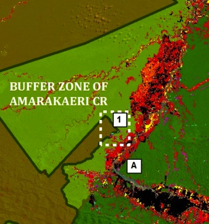
Red, black, and yellow areas show the growing threat of illegal gold mining
Images #2 and #9 map a so-called “sustainable” cacao operation that is actually clearing expanses of primary forest. The focus of an ALERT campaign, the legality of this deforestation is highly questionable.
Images #3 and #7 show that we can detect new logging roads. This is vital because illegal logging is challenging to detect with satellite imagery. But now we can readily find logging roads and point authorities to where illegal loggers are likely active.
Image #8 shows how Landsat and high-resolution imagery can be combined to map a new illegal coca plantation, in this case deep within the proposed Sierra del Divisor National Park.
Finally, Image #4 reveals a rapidly emerging threat, oil palm. Oil palm has caused major impacts in Southeast Asia and is quickly expanding in central and northern Peru.
In the near future, MAAP will continue tracking deforestation in the Andean Amazon while aiming to promote better law enforcement and policies to reduce illegal forest loss.
To receive our reports, just email us (maap@amazonconservation.org) with the word "Subscribe" in the subject line.
MAAP is a groundbreaking effort to shine a light on environmentally irreplaceable areas where illegal loggers, miners, and forest destroyers are running rampant. Please help us to save some of the world's most biologically rich and imperiled ecosystems!